Santa Cruz Surf Report
| Wave height * | 7ft / 2.1m |
|---|---|
| Swell period | 11s |
| Swell direction | |
| Wind | |
| Sea temp | 19°C / 65°F |
10 day Santa Cruz surf forecast
Sat
19/Oct
8.5ft
10
12
10
- High 5:05am
- Low 11:14am
- High 5:29pm
- Low 11:32pm
Sun
20/Oct
7.5ft
7
9
5
- High 5:48am
- Low 12:01pm
- High 6:17pm
Mon
21/Oct
8.5ft
2
5
21
- Low 12:16am
- High 6:37am
- Low 12:55pm
- High 7:13pm
Tue
22/Oct
8ft
23
18
16
- Low 1:08am
- High 7:33am
- Low 2:03pm
- High 8:23pm
Wed
23/Oct
6ft
8
8
4
- Low 2:16am
- High 8:47am
- Low 3:34pm
- High 9:55pm
Thu
24/Oct
4.5ft
10
13
5
- Low 3:54am
- High 10:17am
- Low 5:09pm
- High 11:25pm
Fri
25/Oct
6.5ft
23
25
28
- Low 5:25am
- High 11:37am
- Low 6:17pm
Sat
26/Oct
9.5ft
30
26
29
- High 12:28am
- Low 5:27am
- High 11:36am
- Low 6:04pm
Sun
27/Oct
6.5ft
23
15
23
- High 12:12am
- Low 6:12am
- High 12:20pm
- Low 6:40pm
Mon
28/Oct
4ft
19
17
12
- High 12:47am
- Low 6:47am
Sat 19th Oct
| 4:00 | 6ft | 6.3ft | 11s | 10mph (13mph) | |||
| 7:00 | 6ft | 6.3ft | 11s | 10mph (13mph) | |||
| 10:00 | 7ft | 7.4ft | 11s | 9mph (12mph) | |||
| 13:00 | 8.5ft | 9ft | 13s | 12mph (14mph) | |||
| 16:00 | 9.5ft | 10.2ft | 13s | 12mph (15mph) | |||
| 19:00 | 10ft | 11ft | 16s | 10mph (13mph) |
| Tide times |
|---|
| High 5:05am (3.61m) |
| Low 11:14am (0.50m) |
| High 5:29pm (3.43m) |
| Low 11:32pm (0.68m) |
| Daylight | |
|---|---|
| First light | 07:24 |
| Sunrise | 07:51 |
| Sunset | 18:52 |
| Dark | 19:19 |
Sun 20th Oct
| 4:00 | 9.5ft | 10.6ft | 15s | 7mph (8mph) | |||
| 7:00 | 9ft | 9.8ft | 14s | 7mph (8mph) | |||
| 10:00 | 8.5ft | 9ft | 14s | 9mph (10mph) | |||
| 13:00 | 7.5ft | 8.3ft | 13s | 9mph (10mph) | |||
| 16:00 | 7.5ft | 8ft | 13s | 7mph (7mph) | |||
| 19:00 | 8ft | 8.5ft | 14s | 5mph (5mph) |
| Tide times |
|---|
| High 5:48am (3.43m) |
| Low 12:01pm (0.71m) |
| High 6:17pm (3.14m) |
| Daylight | |
|---|---|
| First light | 07:25 |
| Sunrise | 07:52 |
| Sunset | 18:51 |
| Dark | 19:18 |
Mon 21st Oct
| 4:00 | 8.5ft | 9.4ft | 13s | 3mph (3mph) | |||
| 7:00 | 8.5ft | 9.1ft | 12s | 2mph (2mph) | |||
| 10:00 | 8.5ft | 9.4ft | 12s | 1mph (1mph) | |||
| 13:00 | 8.5ft | 9.5ft | 12s | 5mph (6mph) | |||
| 16:00 | 8.5ft | 9.2ft | 12s | 24mph (27mph) | |||
| 19:00 | 8ft | 8.9ft | 12s | 21mph (24mph) |
| Tide times |
|---|
| Low 12:16am (0.96m) |
| High 6:37am (3.20m) |
| Low 12:55pm (0.96m) |
| High 7:13pm (2.84m) |
| Daylight | |
|---|---|
| First light | 07:26 |
| Sunrise | 07:53 |
| Sunset | 18:50 |
| Dark | 19:17 |
Tue 22nd Oct
| 4:00 | 7.5ft | 8.9ft | 13s | 24mph (26mph) | |||
| 7:00 | 8ft | 8.8ft | 12s | 23mph (25mph) | |||
| 10:00 | 8ft | 8.8ft | 12s | 20mph (21mph) | |||
| 13:00 | 8ft | 8.7ft | 12s | 18mph (19mph) | |||
| 16:00 | 8ft | 8.4ft | 12s | 16mph (17mph) | |||
| 19:00 | 7.5ft | 8.2ft | 11s | 16mph (20mph) |
| Tide times |
|---|
| Low 1:08am (1.25m) |
| High 7:33am (2.96m) |
| Low 2:03pm (1.20m) |
| High 8:23pm (2.59m) |
| Daylight | |
|---|---|
| First light | 07:27 |
| Sunrise | 07:54 |
| Sunset | 18:48 |
| Dark | 19:16 |
Wed 23rd Oct
| 4:00 | 7ft | 7.4ft | 11s | 7mph (7mph) | |||
| 7:00 | 6.5ft | 7.2ft | 12s | 8mph (11mph) | |||
| 10:00 | 6.5ft | 7ft | 12s | 11mph (15mph) | |||
| 13:00 | 6ft | 6.8ft | 12s | 8mph (8mph) | |||
| 16:00 | 6ft | 6.6ft | 12s | 10mph (11mph) | |||
| 19:00 | 6ft | 6.4ft | 12s | 4mph (4mph) |
| Tide times |
|---|
| Low 2:16am (1.49m) |
| High 8:47am (2.77m) |
| Low 3:34pm (1.34m) |
| High 9:55pm (2.46m) |
| Daylight | |
|---|---|
| First light | 07:28 |
| Sunrise | 07:55 |
| Sunset | 18:47 |
| Dark | 19:14 |
Thu 24th Oct
| 4:00 | 5ft | 5.7ft | 11s | 7mph (7mph) | |||
| 7:00 | 5ft | 5.4ft | 11s | 10mph (12mph) | |||
| 10:00 | 5ft | 5.2ft | 11s | 14mph (22mph) | |||
| 13:00 | 4.5ft | 4.9ft | 12s | 13mph (17mph) | |||
| 16:00 | 4ft | 4.7ft | 12s | 12mph (16mph) | |||
| 19:00 | 4ft | 4.5ft | 12s | 5mph (5mph) |
| Tide times |
|---|
| Low 3:54am (1.60m) |
| High 10:17am (2.71m) |
| Low 5:09pm (1.33m) |
| High 11:25pm (2.51m) |
| Daylight | |
|---|---|
| First light | 07:29 |
| Sunrise | 07:57 |
| Sunset | 18:46 |
| Dark | 19:13 |
Fri 25th Oct
| 4:00 | 4.5ft | 4.6ft | 13s | 21mph (21mph) | |||
| 7:00 | 4.5ft | 5.1ft | 13s | 23mph (23mph) | |||
| 10:00 | 5.5ft | 6ft | 13s | 25mph (25mph) | |||
| 13:00 | 6.5ft | 7.1ft | 12s | 25mph (27mph) | |||
| 16:00 | 7ft | 7.8ft | 12s | 26mph (29mph) | |||
| 19:00 | 8ft | 8.8ft | 12s | 28mph (31mph) |
| Tide times |
|---|
| Low 5:25am (1.53m) |
| High 11:37am (2.78m) |
| Low 6:17pm (1.22m) |
| Daylight | |
|---|---|
| First light | 07:30 |
| Sunrise | 07:58 |
| Sunset | 18:44 |
| Dark | 19:12 |
Sat 26th Oct
| 4:00 | 10.5ft | 11.9ft | 15s | 29mph (31mph) | |||
| 7:00 | 10ft | 11.7ft | 14s | 30mph (32mph) | |||
| 10:00 | 9.5ft | 11.2ft | 14s | 29mph (32mph) | |||
| 13:00 | 9.5ft | 10.4ft | 14s | 26mph (27mph) | |||
| 16:00 | 9ft | 9.7ft | 13s | 28mph (30mph) | |||
| 19:00 | 8.5ft | 9.4ft | 13s | 29mph (31mph) |
| Tide times |
|---|
| High 12:28am (2.64m) |
| Low 5:27am (1.38m) |
| High 11:36am (2.91m) |
| Low 6:04pm (1.09m) |
| Daylight | |
|---|---|
| First light | 07:31 |
| Sunrise | 07:59 |
| Sunset | 18:43 |
| Dark | 19:11 |
Sun 27th Oct
| 4:00 | 7ft | 8.2ft | 12s | 22mph (23mph) | |||
| 7:00 | 7ft | 8ft | 12s | 23mph (26mph) | |||
| 10:00 | 6.5ft | 7.7ft | 12s | 22mph (23mph) | |||
| 13:00 | 6.5ft | 7.2ft | 12s | 15mph (14mph) | |||
| 16:00 | 6ft | 6.7ft | 11s | 20mph (22mph) | |||
| 19:00 | 5.5ft | 6.6ft | 11s | 23mph (24mph) |
| Tide times |
|---|
| High 12:12am (2.80m) |
| Low 6:12am (1.21m) |
| High 12:20pm (3.04m) |
| Low 6:40pm (0.98m) |
| Daylight | |
|---|---|
| First light | 06:32 |
| Sunrise | 07:00 |
| Sunset | 17:42 |
| Dark | 18:09 |
Mon 28th Oct
| 4:00 | 5ft | 5.6ft | 11s | 20mph (24mph) | |||
| 7:00 | 4.5ft | 5.4ft | 11s | 19mph (31mph) | |||
| 10:00 | 4ft | 5.2ft | 11s | 21mph (30mph) | |||
| 13:00 | 4ft | 5ft | 11s | 17mph (22mph) | |||
| 16:00 | 4.5ft | 4.9ft | 10s | 15mph (21mph) | |||
| 19:00 | 4ft | 4.9ft | 10s | 12mph (17mph) |
| Tide times |
|---|
| High 12:47am (2.94m) |
| Low 6:47am (1.05m) |
| Daylight | |
|---|---|
| First light | 06:33 |
| Sunrise | 07:01 |
| Sunset | 17:41 |
| Dark | 18:08 |
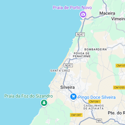
Big, exposed beach that picks up more swell than most of the Ericeira spots and has the bonus of not being too blown out on a S wind. Can get good and packs a punch
Surf spots nearby
- Praia Azul (2.3 mi)
- Praia da Areia Branca (8.8 mi)
- Sao Lourenco (9.2 mi)
- Coxos (10 mi)
- Cave (10.7 mi)
- Ribeira D'Ilhas (10.8 mi)
- Reef (11.2 mi)
- Pedra Branca (11.4 mi)
- Praia do Norte (12.2 mi)
- Praia do Peixe (12.4 mi)
Not Magic Seaweed (MSW)
Although we look a bit like Magic Seaweed we are not MagicSeaweed as they no longer exist...