Lowestoft Surf Report
| Wave height * | 3ft / 0.9m |
|---|---|
| Swell period | 6s |
| Swell direction | |
| Wind | |
| Sea temp | 17°C / 63°F |
10 day Lowestoft surf forecast
Wed
18/Sep
2.5ft
15
16
16
- Low 4:43am
- High 10:46am
- Low 5:18pm
- High 11:35pm
Thu
19/Sep
2.5ft
14
16
15
- Low 5:24am
- High 11:31am
- Low 5:59pm
Fri
20/Sep
2.5ft
14
16
13
- High 12:15am
- Low 6:04am
- High 12:16pm
- Low 6:42pm
Sat
21/Sep
1.5ft
9
10
9
- High 12:55am
- Low 6:46am
- High 1:02pm
- Low 7:24pm
Sun
22/Sep
2ft
10
7
7
- High 1:36am
- Low 7:30am
- High 1:51pm
- Low 8:10pm
Mon
23/Sep
2ft
8
16
14
- High 2:21am
- Low 8:21am
- High 2:47pm
- Low 9:00pm
Tue
24/Sep
0.5ft
8
9
5
- High 3:11am
- Low 9:23am
- High 3:58pm
- Low 10:00pm
Wed
25/Sep
0.5ft
7
7
4
- High 4:12am
- Low 10:41am
- High 5:46pm
- Low 11:22pm
Thu
26/Sep
3ft
8
12
22
- High 5:23am
- Low 12:37pm
- High 7:13pm
Fri
27/Sep
1.5ft
17
19
19
- Low 1:21am
- High 6:44am
- Low 1:45pm
- High 8:13pm
Wed 18th Sep
| 4:00 | 3ft | 4.2ft | 6s | 14mph (21mph) | |||
| 7:00 | 2.5ft | 4ft | 6s | 15mph (23mph) | |||
| 10:00 | 2.5ft | 4.1ft | 5s | 17mph (23mph) | |||
| 13:00 | 2.5ft | 4ft | 5s | 16mph (21mph) | |||
| 16:00 | 2.5ft | 4.1ft | 5s | 17mph (22mph) | |||
| 19:00 | 3ft | 4.3ft | 5s | 16mph (26mph) |
| Tide times |
|---|
| Low 4:43am (0.76m) |
| High 10:46am (2.84m) |
| Low 5:18pm (0.14m) |
| High 11:35pm (2.60m) |
| Daylight | |
|---|---|
| First light | 06:00 |
| Sunrise | 06:34 |
| Sunset | 18:58 |
| Dark | 19:32 |
Thu 19th Sep
| 4:00 | 2.5ft | 3.8ft | 5s | 14mph (24mph) | |||
| 7:00 | 2.5ft | 3.5ft | 5s | 14mph (24mph) | |||
| 10:00 | 2ft | 3.3ft | 5s | 16mph (24mph) | |||
| 13:00 | 2.5ft | 3.4ft | 5s | 16mph (23mph) | |||
| 16:00 | 2ft | 3.3ft | 5s | 16mph (21mph) | |||
| 19:00 | 2ft | 3.3ft | 5s | 15mph (24mph) |
| Tide times |
|---|
| Low 5:24am (0.69m) |
| High 11:31am (2.89m) |
| Low 5:59pm (0.18m) |
| Daylight | |
|---|---|
| First light | 06:02 |
| Sunrise | 06:36 |
| Sunset | 18:55 |
| Dark | 19:29 |
Fri 20th Sep
| 4:00 | 2ft | 3.2ft | 5s | 8mph (12mph) | |||
| 7:00 | 2ft | 2.9ft | 5s | 14mph (23mph) | |||
| 10:00 | 2ft | 2.8ft | 5s | 16mph (23mph) | |||
| 13:00 | 2.5ft | 3.3ft | 5s | 16mph (22mph) | |||
| 16:00 | 2.5ft | 3.7ft | 5s | 16mph (21mph) | |||
| 19:00 | 3ft | 3.8ft | 5s | 13mph (24mph) |
| Tide times |
|---|
| High 12:15am (2.54m) |
| Low 6:04am (0.66m) |
| High 12:16pm (2.87m) |
| Low 6:42pm (0.32m) |
| Daylight | |
|---|---|
| First light | 06:04 |
| Sunrise | 06:38 |
| Sunset | 18:53 |
| Dark | 19:27 |
Sat 21st Sep
| 4:00 | 2.5ft | 3.6ft | 6s | 9mph (13mph) | |||
| 7:00 | 2ft | 3.1ft | 6s | 9mph (12mph) | |||
| 10:00 | 2ft | 2.8ft | 5s | 10mph (13mph) | |||
| 13:00 | 1.5ft | 2.5ft | 5s | 10mph (12mph) | |||
| 16:00 | 1.5ft | 2.4ft | 5s | 10mph (13mph) | |||
| 19:00 | 1.5ft | 2.3ft | 5s | 9mph (16mph) |
| Tide times |
|---|
| High 12:55am (2.45m) |
| Low 6:46am (0.69m) |
| High 1:02pm (2.78m) |
| Low 7:24pm (0.53m) |
| Daylight | |
|---|---|
| First light | 06:05 |
| Sunrise | 06:39 |
| Sunset | 18:51 |
| Dark | 19:25 |
Sun 22nd Sep
| 4:00 | 1.5ft | 2.2ft | 5s | 8mph (13mph) | |||
| 7:00 | 1.5ft | 2.1ft | 4s | 10mph (15mph) | |||
| 10:00 | 2ft | 2.2ft | 4s | 10mph (14mph) | |||
| 13:00 | 2ft | 2ft | 4s | 7mph (8mph) | |||
| 16:00 | 2ft | 2.2ft | 4s | 5mph (6mph) | |||
| 19:00 | 1.5ft | 2.2ft | 4s | 7mph (11mph) |
| Tide times |
|---|
| High 1:36am (2.35m) |
| Low 7:30am (0.77m) |
| High 1:51pm (2.64m) |
| Low 8:10pm (0.79m) |
| Daylight | |
|---|---|
| First light | 06:07 |
| Sunrise | 06:41 |
| Sunset | 18:48 |
| Dark | 19:22 |
Mon 23rd Sep
| 4:00 | 1ft | 1.9ft | 4s | 9mph (16mph) | |||
| 7:00 | 1ft | 1.8ft | 4s | 8mph (14mph) | |||
| 10:00 | 1.5ft | 2.4ft | 4s | 10mph (15mph) | |||
| 13:00 | 2ft | 3ft | 5s | 16mph (18mph) | |||
| 16:00 | 1.5ft | 2.7ft | 5s | 17mph (20mph) | |||
| 19:00 | 1.5ft | 2.5ft | 5s | 14mph (21mph) |
| Tide times |
|---|
| High 2:21am (2.26m) |
| Low 8:21am (0.88m) |
| High 2:47pm (2.47m) |
| Low 9:00pm (1.05m) |
| Daylight | |
|---|---|
| First light | 06:09 |
| Sunrise | 06:43 |
| Sunset | 18:46 |
| Dark | 19:20 |
Tue 24th Sep
| 4:00 | 1.5ft | 2.9ft | 6s | 9mph (17mph) | |||
| 7:00 | 1.5ft | 2.5ft | 6s | 8mph (12mph) | |||
| 10:00 | 1ft | 2.1ft | 5s | 9mph (12mph) | |||
| 13:00 | 0.5ft | 1.7ft | 6s | 9mph (13mph) | |||
| 16:00 | 0.5ft | 1.6ft | 6s | 8mph (12mph) | |||
| 19:00 | 0.5ft | 1.6ft | 7s | 5mph (6mph) |
| Tide times |
|---|
| High 3:11am (2.19m) |
| Low 9:23am (0.99m) |
| High 3:58pm (2.32m) |
| Low 10:00pm (1.28m) |
| Daylight | |
|---|---|
| First light | 06:11 |
| Sunrise | 06:44 |
| Sunset | 18:44 |
| Dark | 19:17 |
Wed 25th Sep
| 4:00 | 0.5ft | 1.7ft | 5s | 7mph (11mph) | |||
| 7:00 | 0ft | 1.9ft | 4s | 7mph (9mph) | |||
| 10:00 | 0.5ft | 1.8ft | 4s | 5mph (7mph) | |||
| 13:00 | 0.5ft | 1.7ft | 5s | 7mph (7mph) | |||
| 16:00 | 0.5ft | 2ft | 4s | 9mph (9mph) | |||
| 19:00 | 1ft | 2.4ft | 4s | 4mph (6mph) |
| Tide times |
|---|
| High 4:12am (2.16m) |
| Low 10:41am (1.06m) |
| High 5:46pm (2.25m) |
| Low 11:22pm (1.41m) |
| Daylight | |
|---|---|
| First light | 06:12 |
| Sunrise | 06:46 |
| Sunset | 18:41 |
| Dark | 19:15 |
Thu 26th Sep
| 4:00 | 2.5ft | 4.3ft | 5s | 9mph (13mph) | |||
| 7:00 | 2.5ft | 4.8ft | 5s | 8mph (12mph) | |||
| 10:00 | 3.5ft | 6ft | 6s | 9mph (9mph) | |||
| 13:00 | 3ft | 5.9ft | 6s | 12mph (12mph) | |||
| 16:00 | 2.5ft | 5ft | 6s | 18mph (23mph) | |||
| 19:00 | 2ft | 4.9ft | 6s | 22mph (28mph) |
| Tide times |
|---|
| High 5:23am (2.18m) |
| Low 12:37pm (0.98m) |
| High 7:13pm (2.29m) |
| Daylight | |
|---|---|
| First light | 06:14 |
| Sunrise | 06:48 |
| Sunset | 18:39 |
| Dark | 19:13 |
Fri 27th Sep
| 4:00 | 1.5ft | 2.6ft | 6s | 19mph (26mph) | |||
| 7:00 | 0.5ft | 2.4ft | 5s | 17mph (24mph) | |||
| 10:00 | 1.5ft | 2.9ft | 4s | 15mph (21mph) | |||
| 13:00 | 1.5ft | 3.2ft | 4s | 19mph (24mph) | |||
| 16:00 | 1.5ft | 3.6ft | 5s | 21mph (28mph) | |||
| 19:00 | 1.5ft | 3.8ft | 6s | 19mph (28mph) |
| Tide times |
|---|
| Low 1:21am (1.38m) |
| High 6:44am (2.24m) |
| Low 1:45pm (0.81m) |
| High 8:13pm (2.34m) |
| Daylight | |
|---|---|
| First light | 06:16 |
| Sunrise | 06:50 |
| Sunset | 18:36 |
| Dark | 19:10 |
Nearest buoys
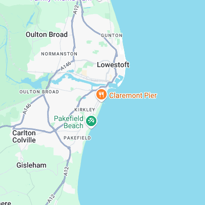
Works best on a N swell but will have waves on E/SE wind swells. Generally fairly weak on account of offshore banks but can be worth a look, particularly towards Claremont Pier
Surf spots nearby
- Gorleston (7.2 mi)
- Walberswick (11 mi)
- Sea Palling (12.7 mi)
- Scratby (15 mi)
Not Magic Seaweed (MSW)
Although we look a bit like Magic Seaweed we are not MagicSeaweed as they no longer exist...