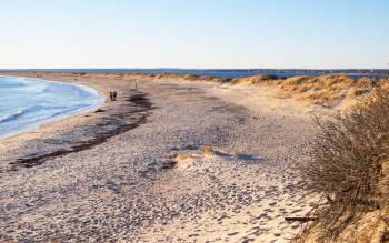
Napatree Point Beach
Set on a narrow spit of sand jutting out towards Connecticut is Napatree Point beach - a lovely arc of near-white sand is backed by low grassy dunes and a small lagoon. The beach sits just to the west of Rhode Island’s exclusive Watch Hill and the bay is overlooked by Watch Hill Lighthouse.
Now a nature reserve the headland here was once the site of an artillery installation. Today all that remains of Fort Mansfield are a couple of ruined gun emplacements.
There’s plenty of wildlife to spot on Napatree Point. As well as resident deer, osprey and foxes, many migratory birds use the area as a rest stop. Napatree is also a nesting location for the endangered piping plover. For this reason dogs are required to be kept on a leash with further restrictions during the summer.
Much has changed at Napatree Point over the years. The name is said to come from “nap” or neck of trees which once covered the point. However virtually all the trees were flattened in the hurricane of 1815.
Then in 1938 another hurricane changed the shape of the island washing away the 1.5 mile sandy extension to the north. This strip of sand now forms Sandy Point Island. At this time there were homes on Napatree, however the hurricane destroyed them all.
Nearest town/city
Pawcatuck
Activities
- Swimming/bathing
Submit a correction
Current weather (Sun Mar 9th 18:00)

(Fair)
6°C / 43°F
Sea temperature
4.1°C39.3°F
What did we get wrong?
Rate Napatree Point Beach
Westerly
Rhode Island
USA
Beaches nearby
- Watch Hill Beach (0.6 mi)
- Ocean House Beach (0.9 mi)
- East Beach (1.8 mi)
- DuBois Beach (2.2 mi)
- Misquamicut Fire District Beach (3.1 mi)
- Misquamicut State Beach (3.7 mi)
- South Beach (4.4 mi)
- Atlantic Beach (4.8 mi)
- Nauyaug Coast (5.2 mi)
- Westerly Town Beach (5.3 mi)


